
Forecasters warn of 'brutal,' potentially deadly storm system arriving Wednesday
International
- 4-01-2023, 09:34
INA- sources
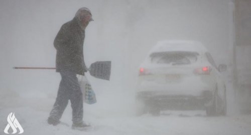
After experiencing an atmospheric river that soaked Northern California New Year's weekend, Bay Area residents prepared for another, even stronger storm system set to arrive Wednesday that weather forecasters warn could have catastrophic impacts.
A new weather system was predicted by afternoon or evening, but the National Weather Service (NWS) said the rain would be modest until the arrival late Tuesday of another strong atmospheric river delivering a long plume of Pacific Ocean moisture.
The Bay Area office of the National Weather Service did not mince words about the approaching atmospheric river, warning it could have catastrophic impacts across the region.
"To put it simply, this will likely be one of the most impactful systems on a widespread scale that this meteorologist has seen in a long while," the statement read. "The impacts will include widespread flooding, roads washing out, hillside collapsing, trees down (potentially full groves), widespread power outages, immediate disruption to commerce, and the worst of all, likely loss of human life. This is truly a brutal system that we are looking at and needs to be taken seriously."
Storms are also expected to drench the area through Friday, with the strongest rain arriving Wednesday morning and continuing until around midnight, according to KPIX meteorologist Brian Hackney.
The NWS issued a flood watch from Wednesday at 4 a.m. to Thursday at 4 p.m.
The NWS added that unlike previous winter storms that blew in from east to west, this new storm system looks like it will run north to south and the heaviest rainfall will hit the coastal mountains all at the same time.
"Bottom line for this week is that for the Jan 4-5 storm, expect similar impacts or worse compared to what happened on Dec 31. Rapid rises on creeks and streams, downed trees, multiple mudslides across the region, power outages," a statement from the NWS read. "In addition, this third atmospheric river since Dec. 26 means we could see some of our main stem rivers approach or reach flood stage. One area of concern is the Russian River near Guerneville."
The NWS suggested that residents that live in areas with one road should have extra supplies on hand in case that road floods or is blocked by mudslides and or downed trees. Emergency crews will likely be busy with widespread storm impacts so power outages and closed roads may not be resolved right away.
Additionally, the Bay Area office of the National Weather Service issued a High Wind Watch for much of Northern California stretching from Mendocino County south to Monterrey County. Officials say the winds are expected to be much stronger than during the storm on Saturday.
Rainfall in downtown San Francisco hit 5.46 inches on New Year's Eve, making it the second-wettest day on record, behind a November 1994 deluge, the National Weather Service said.
Even with the respite from drenching rains and heavy snowfall, flood warnings and watches remained in effect in the Sacramento County area, where widespread flooding and levee breaches in the agricultural region inundated roads and highways.
Emergency crews rescued motorists on New Year's Eve into Sunday morning. Crews on Sunday found one person dead inside a submerged vehicle near Highway 99, Dan Quiggle, deputy fire chief for operations for Cosumnes Community Service District Fire Department, told The Sacramento Bee.
Sacramento County authorities issued an evacuation order late Sunday for residents of the low-lying community of Point Pleasant near Interstate 5, citing imminent and dangerous flooding. Residents of the nearby communities of Glanville Tract and Franklin Pond were told to prepare to leave before more roadways were cut off by rising water and evacuation becomes impossible.
"It is expected that the flooding from the Cosumnes River and the Mokelumne River is moving southwest toward I-5 and could reach these areas in the middle of the night," the Sacramento County Office of Emergency Services tweeted Sunday afternoon. "Livestock in the affected areas should be moved to higher ground."
To the north in the state's capital, crews cleared toppled trees from roads and sidewalks, and at least 6,300 customers still lacked power early Monday, down from more than 150,000 two days earlier, according to a Sacramento Municipal Utility District online map.
State highway workers spent the holiday weekend clearing traffic-stopping heavy snow from major highways through the Sierra Nevada.
Near Lake Tahoe, dozens of drivers were rescued on New Year's Eve along Interstate 80 after cars spun out in the snow during the blizzard, the California Department of Transportation said.
In Southern California, several people were rescued after flood waters inundated cars in San Bernardino and Orange counties. No major injuries were reported.
With no rainfall expected during Monday's Rose Parade in Pasadena, spectators staked out their spots along the city's main boulevard for the 134th edition of the floral spectacle.
source: CBS NEWS
Related news

Fourth death confirmed in Netherlands as Storm Eunice heads north
- International
- 09:52

Storm Eunice batters Europe killing at least 8 people
- International
- 09:29
Storm Battering Western Alaska Causes Widespread Flooding
- International
- 09:19


Prime Minister inaugurates new Nineveh Governorate building
- politics
- 04:30


US Central Command: We killed ISIS terrorist leader Abu Yusuf in Syria
- International
- 24/12/20

Liverpool compete with Real Madrid to sign Olympique Lyonnais star
- Security
- 24/12/19

ISC, ADX discuss Strengthening Economic Ties
- Economy
- 24/12/16

Iraq assumes presidency of Arab Investment Company’s Executive Board
- Economy
- 24/12/17