Earth's crust is dripping 'like honey' into its interior under the Andes
Multimedia
- 23-07-2022, 08:45
INA- sources
Earth's crust is dripping "like honey" into our planet's hot interior beneath the Andes mountains, scientists have discovered.
By setting up a simple experiment in a sandbox and comparing the results to actual geological data, researchers have found compelling evidence that Earth's crust has been "avalanched away" across hundreds of miles in the Andes after being swallowed up by the viscous mantle.
Nature: Communications Earth & Environment
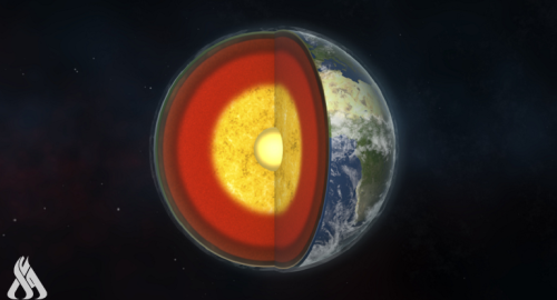
The outer regions of the Earth’s geology can be broken down into two parts: a crust and upper mantle that form rigid plates of solid rock, the lithosphere; and the hotter, more pressurized plastic-like rocks of the lower mantle. Lithospheric (or tectonic) plates float on this lower mantle, and its magmatic convection currents can pull the plates apart to form oceans; rub them against one another to trigger earthquakes; and collide them, slide one under the other, or expose a gap in the plate to the mantle’s fierce heat to form mountains. But, as scientists have begun observing, these aren’t the only ways that mountains can be formed.
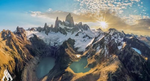
The Central Andean Plateau consists of the Puna and Altiplano plateaus — a roughly 1,120-mile-long (1,800 kilometers), 250-mile-wide (400 km) expanse that stretches from northern Peru through Bolivia, southwestern Chile and northwestern Argentina. It was created by the subduction, or the slipping beneath, of the heavier Nazca tectonic plate under the South American tectonic plate. This process deformed the crust above it, pushing it thousands of miles into the air to form mountains.
These are all signs of lithospheric dripping. But to be sure, the scientists needed to test that hypothesis by modeling the plateau's ground. They filled a plexiglass tank with materials that simulated Earth's crust and mantle, using polydimethylsiloxane (PDMS), a silicon polymer around 1,000 times thicker than table syrup, for the lower mantle; a mixture of PDMS and modeling clay for the upper mantle; and a sand-like layer of tiny ceramic spheres and silica spheres for the crust.
By comparing the images of their model's surface to aerial images of the Andes’ geological features, the researchers saw a marked similarity between the two, strongly suggesting that the features in the Andes had indeed been formed by lithospheric drip.
source: Live Science
Related news
Geologists analyze two strange points discovered deep in the earth
- Multimedia
- 10:17

Scientists discover a way to see the beginnings of the universe
- Multimedia
- 09:25
Jupiter’s moon Europa may be hiding alien life under its icy shell
- Multimedia
- 10:12


Egypt announces payment of $38.7 billion of its debts
- International
- 09:58


Syria: Imposing a curfew in the city of Homs
- International
- 07:45

US Central Command: We killed ISIS terrorist leader Abu Yusuf in Syria
- International
- 24/12/20

Liverpool compete with Real Madrid to sign Olympique Lyonnais star
- Security
- 24/12/19


7 ISIS elements arrested in Kirkuk
- Security
- 24/12/20