A 40-million-year-old River buried beneath Antarctic ice discovered
Multimedia
- 22-06-2024, 08:58
INA-sources
Millions of years ago, Antarctica looked vastly different from the icy landscape we know today.
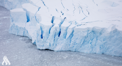
A research expedition led by the Alfred Wegener Institute has uncovered a hidden secret. Geologists discovered evidence of an ancient river system by studying sediment samples from the Amundsen Sea.
This suggests that Antarctica supported a temperate climate around 34 million years ago, during which lush forests thrived and a vast network of rivers carved their way across the landscape.
Examination of sediments
Earth underwent a dramatic cooling period between 34 and 44 million years ago. This “middle to late Eocene” period saw a drastic drop in carbon dioxide levels, forming the first glaciers on an otherwise ice-free Earth.
Scientists have long wondered how this event played out in Antarctica, a continent now dominated by ice.
Antarctica wasn’t a lonely continent at the time. Until around 100 million years ago, it was part of a massive continent known as Gondwana. As Gondwana broke apart, Antarctica moved south and established its continent.
Even though it shifted to the South Pole, Antarctica experienced temperate climate conditions until the end of the Eocene, around 34 million years ago.
This new study involved an international team of researchers studying the minerals and rock fragments found in sediment samples from the Amundsen Sea off the West Antarctic coast. The samples were collected during an expedition onboard the research icebreaker Polarstern.
Surprisingly, most of these minerals and fragments came from somewhere other than West Antarctica, where they were found. Instead, they point to a distant source – the Transantarctic Mountains on the opposite side of the continent, thousands of kilometers away.
As per the press release, this mountain range hasn’t always been so tall. However, they have been progressively growing since the late Eocene epoch.
This rise is linked to a geological feature called the West Antarctic Rift System. This split separates Antarctica into two geographical masses: East and West.
The uplifting of mountains
So, how does this all connect to the ancient river?
The uplifting of the Transantarctic Mountains created a massive amount of erosion debris, which consisted of weathered and moved rocks and minerals.
The newly found river system most likely moved this debris over a long distance (about 1,500 kilometers) via the West Antarctic Rift System before depositing it in the Amundsen Sea.
“The existence of such a transcontinental river system shows that – unlike today – large parts of West Antarctica must have been located above sea level as extensive, flat coastal plains,” said Professor Cornelia Spiegel from the University of Bremen.
As per the press release, West Antarctica had a low topography at the end of the Eocene epoch. Despite being in the South Pole, West Antarctica was not cold enough for permanent ice sheets to form due to its low elevation.
In contrast, East Antarctica‘s mountainous areas, which had greater elevations and lower temperatures, were already witnessing the beginnings of glaciers at the time.
The researchers suggest similar river systems exist today in places with geological features like the West Antarctic Rift System. For instance, the Rio Grande flows through the Rio Grande Rift, whereas the Rhine River travels through the Upper Rhine Graben.
Source: Interesting Engineering


NASA pays tribute to Gagarin in honor of Cosmonautics Day
- Multimedia
- 10:12


White House: Talks with Iran were very positive and constructive
- International
- 09:40


US Embassy: Trade Mission of 60 Companies Visits Iraq
- politics
- 25/04/07


CBI unveils comprehensive reform plan to modernize banking sector
- Economy
- 25/04/07

Al-Sudani Meets Delegation from J.P. Morgan Bank
- politics
- 25/04/08